 LT
LT
 LV
LV
 EE
EE
 EN
EN
 DE
DE
 PL
PL
Overview
-
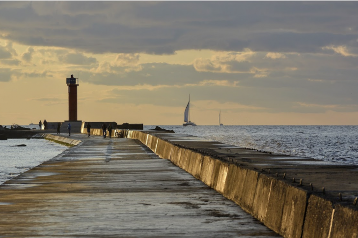
Mangaļsala Pier and Lighthouse
The Mangaļsala (Eastern) pier was built between 1850 and 1861. It reaches a length of 2,240 meters. A lighthouse is installed at the end of the pier. The lighthouse is 7 meters high, with its light positioned 11.5 meters above sea level, illuminating a radius of 4 nautical miles.
This spot is especially attractive at sunset or during storms. -
Walking Trail
In the nature park “Piejūra,” there is a walking trail leading all the way to the seashore. Benches and sports equipment are set up along the trail. The path goes through a forest, past marshes, and over dunes. -
Concrete Ship Island “Lady Cotlin”
At the end of the walking trail, 230 meters from the shore, the bow of the Swedish concrete ship “Lady Cotlin” rises above the sea. It ran aground during a storm in 1951 while transporting salt to Riga. -
Recreation Area
At the end of the walking trail, the recreation area offers sun loungers, bike stands, exercise equipment, a children's playground, and swings. -
Ruins of Soviet Bunkers and Batteries
In the forests of Mangaļsala, you can also find parts of coastal batteries and forts that are under state protection. These structures stretch for more than three kilometers along the seashore, from the mouth of the Daugava River almost to the village of Vecāķi. Some buildings have been preserved since the times of the Russian Empire (1874–1912).